Hurricane Nigel, the sixth hurricane of this Atlantic Ocean season, has rapidly evolved into a Category 1 storm, and meteorologists predict it will undergo “rapid intensification” to become a major hurricane by Tuesday.
- Hurricane Nigel’s Development: Nigel initially formed in the central Atlantic on Saturday but gained strength quickly, officially becoming a Category 1 hurricane on Monday, packing sustained winds of 80 miles per hour.
- Anticipated Rapid Intensification: The National Weather Service (NWS) and National Hurricane Center anticipate Nigel will escalate to a Category 3 hurricane by Tuesday, with sustained winds exceeding 111 miles per hour.
- Current Location: As of Monday morning, Nigel was situated approximately 900 miles southeast of Bermuda and moving northwestward, although it is not expected to make landfall, and no warnings or watches have been issued.
- Projected Path: Nigel is projected to veer into the open Atlantic Ocean by Wednesday, according to the latest forecasts from the National Hurricane Center.
- Potential Weakening: While Nigel is forecasted to become a major hurricane on Tuesday, the NHC suggests that a gradual weakening trend could begin by Wednesday.
Understanding Hurricane Categories:
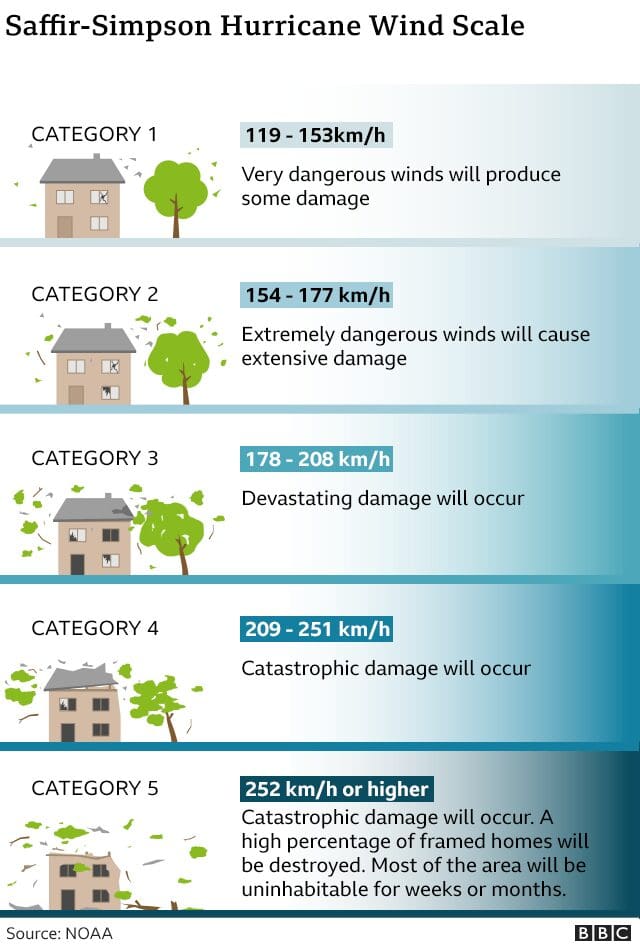
Hurricanes are categorized on the Saffir-Simpson Hurricane Wind Scale based on their sustained wind speeds:
- Category 1: Winds of 74 to 95 mph. “Very dangerous winds will produce some damage.”
- Category 2: Winds of 96 to 110 mph. “Extremely dangerous winds will cause extensive damage.”
- Category 3: Winds of 111 to 129 mph. “Devastating damage will occur.”
- Category 4: Winds of 130 to 156 mph. “Catastrophic damage will occur.”
- Category 5: Winds of 157 mph or higher. “Catastrophic damage will occur.”
Why Rapid Intensification Matters:
Rapid intensification refers to a hurricane’s swift transformation from a lower category to a higher one, often within just two days. Such hurricanes pose significant threats due to limited preparation time and increased destructive potential. Over the past three decades, many Category 3 or higher hurricanes have undergone rapid intensification, attributed to factors like warmer ocean waters, increased atmospheric moisture, and low vertical wind shear.
What’s Next for Hurricane Nigel:
Meteorologists do not foresee Nigel making landfall. Instead, it is expected to continue its northwesterly trajectory, ultimately veering right into the middle of the Atlantic Ocean. Hurricane season lasts until the end of November, with mid-September typically marking its peak.
Stay Informed:
As Nigel’s path unfolds, it’s crucial to stay informed through official channels, follow local advisories, and take necessary precautions if you reside in hurricane-prone areas.
Please keep an eye on the latest updates from reputable sources, such as the National Hurricane Center, to stay safe during this hurricane season.
Are you in need of residential storm damage roofing services or products ?
Alliance Specialty Contractor, Inc. is a GAF Certified Contractor and a Full Service, Veteran Owned, Roofing companies near you that specializes in handling Storm Damage and Insurance Claims! We are the #1 source for all your roofing needs and your full-service roofing company that specializes in Storm damage roof replacement for all properties. We offer roof financing for your roof replacement.
You can count on our highly skilled team to provide fast and reliable free roofing inspections. We deal directly with insurance to ensure you receive the coverage you deserve and provide the best products from GAF. Are you in the Pittsview, Seale, Salem, La Grange, Shiloh, Phenix City, Auburn, Opelika, Columbus, Midland, Ft. Mitchell, Salem, Fortson, or Smiths Station?
Contact Us Today!
(877) STORM-11
Leave a Reply